Have you ever opened a property map of Arizona and felt like you were looking at a giant game board?
It’s a strange sight that leaves many new landowners feeling a bit confused.
You might see a perfect grid of squares stretching out across the desert for miles. Some squares are private land, while some squares belong to the government.
This checkerboard pattern has existed for over 100 years, and most landowners don’t realise how much it affects them. It shapes how you access your property, what you can do with it, and what it’s worth when you sell.
We want to help you understand this puzzle so you don’t get stuck with land you can’t use. If you know the rules of the board, you can win the game of land ownership.
Important Terms For Every Arizona Landowner
Before we get into the details, a few key terms are worth knowing…
Is Your Property Landlocked?
The first word you need to know is Landlocked, which means your property is surrounded by other people’s land on all sides.
It’s like an island in the middle of a lake but with no boat to get there. If your land is landlocked, you might not have a legal way to drive to it.
Is Your Property an Inholding?
Another important word is Inholding. An inholding is a piece of private land that sits inside a big area of public land.
Imagine a tiny dot of private dirt inside a huge National Forest or a park. These lots are often very quiet and pretty, but they have very strict rules.
Do You Need an Easement?
You also need to understand what an Easement is. This is a legal paper that gives you the right to cross someone else’s land.
It’s like a hall pass that lets you use a neighbor’s driveway to reach your house. Without this paper, a neighbor can tell you to stay off their property.
What About State Trust Land?
Finally, we have Arizona’s State Trust Land. This is state-owned land used to make money for schools and hospitals. You may even need a special permit just to walk or drive on this type of land.
How The Railroads Created The Arizona Checkerboard
The story of our land maps starts way back in the 1860s, when the government wanted to build a railroad to the Pacific Ocean.
They didn’t have enough money to pay the railroad companies in cash, so they paid them with land instead.
The government gave the companies every other square mile of land along the tracks. It was a giant “thank you” for building the tracks that moved people and goods.
The railroad got the odd-numbered squares, and the government kept the even-numbered ones. This created a map that looks exactly like a black-and-white checkerboard.
The railroad companies eventually sold their squares to ranchers and farmers. Meanwhile, the government kept their squares or gave them to the State of Arizona later.
That’s why your neighbor might be a private family or a huge government office. This is what makes the Arizona desert so different from the land back East.
Why Access Rules Change Based On Your Neighbor
Let’s be honest: accessing your property is the most important part of owning land. If you can’t get to it, you can’t build a house or enjoy a campfire.
In a checkerboard area, your neighbor might have different rules than you do:
- If your neighbor is the Bureau of Land Management, they might let you drive across.
- If your neighbor is a private rancher, they might put up a “No Trespassing” sign.
The rules for State Trust land are even more complicated for most folks. You can’t just assume that a dirt road on the map is open for everyone, because:
- Some roads are only for government trucks or utility workers.
- Private owners can block roads that cross their personal squares.
- State Trust land often requires a yearly permit for any type of access.
- Public land might be closed during the summer to prevent forest fires.
It’s a big headache when you’re trying to sell your Arizona land since buyers want assurance they can access the entire property. They’ll ask for proof that the road is legal and won’t be closed later.
If you don’t have that proof, the value of your land might drop. It’s always better to find this out before you plant a “For Sale” sign in the dirt.
The Problem With Corner Crossing In Arizona
There’s a famous problem in checkerboard areas called corner crossing. This happens when you try to step from one private square to another at the corner.
Why This is an Issue
This is a problem because you’re technically crossing through the air of the two government squares next to you.
Some people think this should be allowed because it’s such a tiny space. Yet many law experts and landowners say it’s still trespassing.
It has caused huge fights in courts across the West and it makes it very hard to use land that doesn’t have a main road through it.
This is why some land stays empty for decades without any buildings.
Pro Tip: You’ve got to be careful when you’re looking at land that only touches at a point. It’s usually better to look for land with a long side touching a public road.
How To Research Your Land Ownership For Free
You don’t have to be a lawyer to figure out who owns the squares around you.
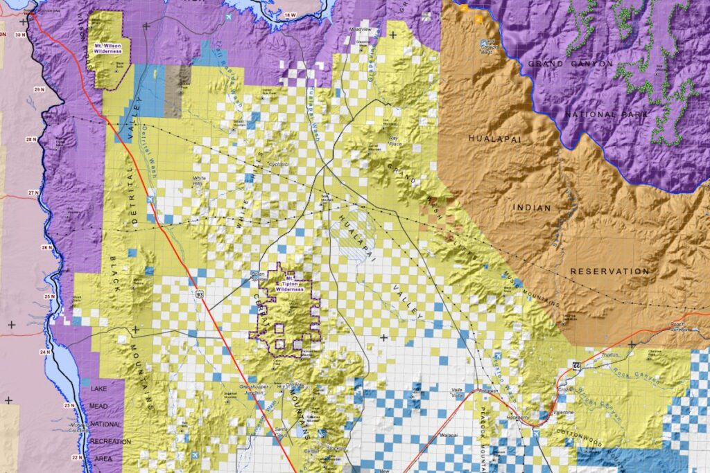
Most Arizona counties have a special website called a GIS map. GIS is a map tool that stands for Geographic Information System.
You can type in your parcel number and see a colorful map of the area, with each color standing for a different type of owner:
- Yellow squares usually belong to the federal government or the BLM.
- Blue squares are almost always State Trust land for the schools.
- Green squares are often National Forest land where the trees are protected.
- White or clear squares are usually private land owned by people like you.
Take a look at the Mohave County example below:
Here’s how to learn about your neighborhood:
- Check the Mohave County or Yavapai County websites for their map tools.
- Look for the name of the owner on the square right next to yours.
- See if there’s a line that shows a public easement or a county road.
- Call the county recorder’s office if you need help finding old papers.
These maps are great, but they aren’t always perfect or up to date.
You should always double-check the information with a title company. A title company can look at the history of the land for the last 100 years and tell you if any secret rules exist.
It’s a small price to pay to ensure your land is easy to sell later.
A Realistic Timeline For Fixing Access Issues
If you find out your land is landlocked, don’t worry too much yet. There are ways to fix it, but it takes some time and work.
Step 1: Request an Easement
Start the process by talking to your neighbors and asking for a legal easement. Most people are nice if you’re friendly and explain what you’re doing.
Note that you might have to pay them some money for the right to use their road.
Step 2: Create a Legal Agreement
Next, you’ll need to hire a lawyer to write down the agreement. This ensures the right stays with the land even if the neighbor sells.
If you have to deal with the state, it can take a bit longer, since the State Land Department has many forms and rules to follow.
They want to ensure the land is safe, and the schools get paid. It’s a slow process, but it’s important for your property value.
The Martinez Family and The Hidden Gate
Let’s look at what happened to the Martinez family when they tried to sell. They had a 20-acre lot that had been in the family since the 1970s.
On the map, it looked like the land was alongside a government park. They thought the road through the park was the best way to get there.
| Step of the Process | Time Frame | Cost Estimate |
| Checking the GIS Map | Day 1 | $0 |
| Calling the BLM Office | Week 1 | $0 |
| Hiring a Land Surveyor | Month 1 | $800 |
| Getting a Legal Paper | Month 2 | $500 |
The family found out the park road was only for government trucks and they weren’t allowed to use it to get to their private cabin.
They had to talk to a private neighbor on the other side of their land. The neighbor was happy to help but wanted a small fee to use the road. They also paid a professional land surveyor to officiate the process.
It took about 2 months to get all the papers signed and recorded, but once they had the legal easement, the land was worth much more.
They sold it to a developer who wanted to build a retreat. Without that work, the land might still be sitting there empty today.
Why Your Property Value Changes With The Checkerboard
The value of land in Arizona isn’t just about the dirt or the view. It’s mostly about how easy it is for someone to use that land.
- In a checkerboard area, a lot with a paved road is worth the most.
- A lot with a legal dirt easement is worth a little bit less.
- A landlocked lot is usually worth the least amount of money, as most people don’t want to spend time fighting for access.
Keep in mind that banks also won’t give out loans for land without a legal road. So if a buyer can’t get a loan, they probably won’t buy your land.
If you fix the access yourself, you can keep more of the money. A little bit of work now can lead to a big payday later.
How To Deal With State Trust Land Rules
State Trust land is a big part of the Arizona checkerboard puzzle, with the land held in a trust for different groups.
The biggest group is the public school system for all the kids in the state. The state has a legal job to make as much money as possible from this land.
They do this by selling the land or renting it out for things like grazing. If your road crosses this land, you are technically using a state asset.
You have to apply for a Right of Way permit to use that road legally.
To do this:
- You’ll need to fill out a long application with the state office.
- You’ll have to provide a map of exactly where the road goes.
- There’s usually a fee you have to pay every year or every 10 years.
- The state can say no if they think the road will hurt the land.
It sounds like a lot of work, but it’s the only way to be safe.
If you use the road without a permit, you’re technically trespassing on school land. Plus, having that permit in your hand makes your land much more attractive to buyers.
Why Some Neighbors Are Harder To Work With
In a checkerboard area, you might have 4 or 5 different neighbors.
Some might be friendly families who have lived there for a long time. Others might be big companies or government agencies that move slowly.
Private owners are usually the easiest people to talk to about access. Big companies can be harder because they have a lot of lawyers and rules. They might not want to give you an easement since it’s too much work for them.
The government is the slowest neighbor of all when it comes to land. They have a lot of red tape and meetings before they can sign any paper.
You have to be very patient and keep calling them to check on your request.
But don’t get discouraged if it takes a few months to get an answer. It’s just the way the system works in the Arizona desert.
Honest Guidance For Selling Your Land Today
Selling land in a checkerboard area takes more legwork than a standard property sale. You’re dealing with maps, county offices, state agencies, and neighbours who may or may not be cooperative.
It’s a lot of stress for someone who just wants to sell their property.
We always tell folks to be very honest about the access from the start. If the land is landlocked, say so in your listing or your talks.
It’s much better than having a buyer find out right before they sign the papers. Being open and clear helps you find the right buyer who is ready to help.
If you’d rather not spend months working through access issues before you can even think about selling, that’s a valid choice too. We’ve worked through enough Arizona checkerboard situations to know what questions to ask and what the obstacles usually are.
We buy land in as-is condition, including landlocked parcels and properties with access complications, and we can usually give you a straightforward answer about what we can offer without a lot of back and forth.
Either path can work. It mostly comes down to how much time and energy you want to put in, and what the land is worth to you.